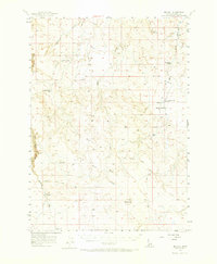
1956 Map of Big Hill
USGS Topo · Published 1973About this map
Wickahoney Crossing and the surrounding high desert plateaus of Owyhee County are defined by a network of seasonal water sources and primitive transportation routes in this mid-century survey. The landscape is marked by unique geologic features like Hole in Rock, while vital water points such as Deer Water Spring and Broken Wagon Flat Reservoir indicate the region's historical reliance on managed water for ranching. The drainage systems of Big Jacks Creek, Wickahoney Creek, and Sugar Creek carve through the terrain, dictating the placement of the Battle Creek Road and several unnamed jeep trails. This survey captures a moment when travel through this part of Idaho still depended heavily on established landmarks and backcountry paths like the Parker Trail, long before modern infrastructure altered the navigation of these canyons and gulches.
Find a feature on this map
20 named features on this map. Tap any name to fly to it.
Don’t see what you’re looking for? This feature index may not catch every label — zoom into the map to look around manually.
Map Details
Editions of this 1956 Big Hill Map
2 editions found

Other maps of this area

1947 · Little Valley
USGS Topo · 1:24,000

1947 · Grand View
USGS Topo · 1:62,500

1947 · Bruneau
USGS Topo · 1:62,500

1947 · Sugar Valley
USGS Topo · 1:24,000

1947 · Hot Spring
USGS Topo · 1:24,000

1947 · Chalk Hills
USGS Topo · 1:24,000
1948 · Little Valley
USGS Topo · 1:24,000
1948 · Chalk Hills
USGS Topo · 1:24,000

1948 · Sugar Valley
USGS Topo · 1:24,000

1948 · Indian Cove
USGS Topo · 1:62,500