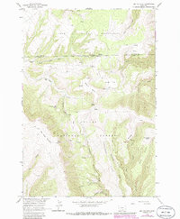
1964 Map of Big Ice Cave
USGS Topo · Published 1986About this map
High-elevation Montana terrain defines this 1964 survey, where the Crow Indian Reservation meets the northern reaches of the Custer National Forest. The landscape is dominated by the geological formations of Big Pryor Mountain, characterized by distinctive features such as Big Ice Cave and Crater Ice Cave. Cattle ranching and seasonal habitation are evidenced by Greenough Ranch and Schwend Ranch, while more isolated sites like Trappers Cabin Spring suggest a long history of wilderness utilization.
Find a feature on this map
38 named features on this map. Tap any name to fly to it.
Don’t see what you’re looking for? This feature index may not catch every label — zoom into the map to look around manually.
Map Details
Editions of this 1964 Big Ice Cave Map
2 editions found
Other maps of this area

1954 · Billings
USGS Topo · 1:250,000

1957 · Billings
USGS Topo · 1:250,000

1958 · Billings
USGS Topo · 1:250,000

1964 · Big Ice Cave
USGS Topo · 1:24,000

1964 · Red Pryor Mountain
USGS Topo · 1:24,000

1964 · East Pryor Mountain
USGS Topo · 1:24,000
1964 · Mystery Cave
USGS Topo · 1:24,000

1967 · Deep Creek SE
USGS Topo · 1:24,000

1967 · Castle Rocks
USGS Topo · 1:24,000

1967 · Deep Creek SW
USGS Topo · 1:24,000