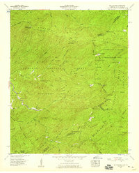
1957 Map of Big Junction
USGS Topo · Published 1959About this map
Cherokee National Forest and Nantahala National Forest converge at the high-altitude border of Tennessee and North Carolina in this mid-century survey. The landscape is defined by heavy timber and water management, visible in the Bemis Logging Camp and the Pheasant Field Rearing Pools along the Tellico River. The 1950s era of this map shows a region dedicated to conservation and wildlife restoration, with large swaths of land designated as the Tellico Wildlife Management Area and the Santeetlah Wildlife Management Area. Higher elevations are marked by prominent points like Haw Knob and Bob Bald, while the Hemlock Knob Lookout Tower serves as a critical fire watch station overlooking Eagle Gap. Local infrastructure is sparse, centered around the Tellico River Lodge and isolated structures like Rains Cabin.
Find a feature on this map
99 named features on this map. Tap any name to fly to it.
Don’t see what you’re looking for? This feature index may not catch every label — zoom into the map to look around manually.
Map Details
Editions of this 1957 Big Junction Map
4 editions found

Other maps of this area

1893 · Murphy
USGS Topo · 1:125,000

1914 · Murphy
USGS Topo · 1:125,000

1927 · Big Junction
USGS Topo · 1:24,000

1933 · Haw Knob
USGS Topo · 1:48,000

1933 · Whiteoak Flats
USGS Topo · 1:24,000

1933 · Bald River Falls
USGS Topo · 1:24,000

1933 · Rafter
USGS Topo · 1:24,000

1934 · McDaniel Bald
USGS Topo · 1:24,000

1934 · Unaka
USGS Topo · 1:24,000

1934 · Murphy
USGS Topo · 1:48,000