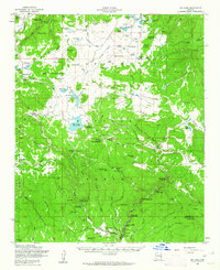
1958 Map of Big Lake
USGS Topo · Published 1962About this map
The Apache National Forest dominates this mid-century high-country survey, revealing a landscape defined by seasonal camps and ranching outposts. Isolated holdings like the Voigt Ranch and Phelps Ranch sit alongside the winding headwaters of the Little Colorado River, where the terrain transitions from timbered ridges to open cienegas. Recreational and agricultural water management is central to the area, evidenced by the Lee Valley Reservoir and numerous named springs that supported both timber operations and local grazing.
Find a feature on this map
100 named features on this map. Tap any name to fly to it.
Don’t see what you’re looking for? This feature index may not catch every label — zoom into the map to look around manually.
Map Details
Editions of this 1958 Big Lake Map
4 editions found

Other maps of this area

1886 · St Johns
USGS Topo · 1:250,000

1892 · St Johns
USGS Topo · 1:250,000

1922 · Nutrioso
USGS Topo · 1:125,000

1954 · Clifton
USGS Topo · 1:250,000

1954 · Saint Johns
USGS Topo · 1:250,000

1957 · Clifton
USGS Topo · 1:250,000

1957 · Saint Johns
USGS Topo · 1:250,000

1958 · Clifton
USGS Topo · 1:250,000

1958 · Saint Johns
USGS Topo · 1:250,000

1958 · Alpine
USGS Topo · 1:62,500