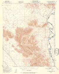
1951 Map of Big Maria Mts
USGS Topo · Published 1952About this map
Big Maria Mountains dominate this 1951 topographic study, rising sharply between the arid expanse of Rice Valley and the winding course of the Colorado River. The landscape reveals a stark contrast between the desert interior, marked by extensive Sand Dunes and isolated peaks like Black Hill, and the developed riverfront. Along the eastern edge, human activity is concentrated near the water, where the Indian Reservation Bdy meets the river. Small riverside outposts like River Bend Lodge, Hills Ranch, and the Blythe Boat Club suggest a mid-century economy built around river access and recreation. Transportation in the southern reach is defined by the Atchison Topeka and Santa Fe railroad and the Midland Road, which provides a corridor for inland travel. Scattered Prospect markings across the desert floor hint at the region's enduring interest for mineral exploration during this post-war era.
Find a feature on this map
16 named features on this map. Tap any name to fly to it.
Don’t see what you’re looking for? This feature index may not catch every label — zoom into the map to look around manually.
Map Details
Editions of this 1951 Big Maria Mts Map
3 editions found

Other maps of this area

1911 · Parker
USGS Topo · 1:125,000

1931 · Moon Mtn
USGS Topo · 1:62,500

1932 · Moon Mtn
USGS Topo · 1:62,500

1933 · Cunningham Mtn
USGS Topo · 1:48,000

1940 · Dome Rock Mts
USGS Topo · 1:62,500

1942 · Blythe
USGS Topo · 1:250,000

1942 · MOON MTN
USGS Topo · 1:62,500

1943 · Parker
USGS Topo · 1:62,500

1943 · Vidal
USGS Topo · 1:62,500

1945 · Big Maria Mtns
USGS Topo · 1:62,500