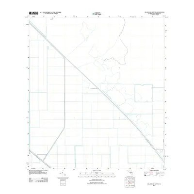
2012 Map of Big Mound South
USGS Topo · Published 2012About this map
Big Mound rises as a distinct landmark in this interior section of Palm Beach County, where the landscape is defined by the massive drainage and irrigation projects of the Florida Everglades. The map illustrates a highly organized grid of agricultural fields and water management features, most notably the diagonal course of the L-8 Canal and the West Palm Beach Canal. These waterways represent the essential infrastructure that transformed the regional wetlands into productive land. While the western portion of the map remains largely dominated by large-scale tracts, the southeastern corner shows the early fingers of residential expansion with local routes like 59th Ln N, 208th Trl, and Dennis St beginning to divide the territory. This 2012 survey captures the area in a state of managed transition between deep agricultural use and the encroaching suburban grid.
Find a feature on this map
6 named features on this map. Tap any name to fly to it.
Don’t see what you’re looking for? This feature index may not catch every label — zoom into the map to look around manually.
Map Details
Editions of this 2012 Big Mound South Map
This is the sole edition of this map. No revisions or reprints were ever made.
Other maps of this area

1956 · West Palm Beach
USGS Topo · 1:250,000

1957 · West Palm Beach
USGS Topo · 1:250,000

1958 · West Palm Beach
USGS Topo · 1:250,000

1970 · West Palm Beach 2 SW
USGS Topo · 1:24,000

1970 · Loxahatchee NW
USGS Topo · 1:24,000
1970 · West Palm Beach 2 NE
USGS Topo · 1:24,000

1970 · Bryant
USGS Topo · 1:24,000

1970 · Sixmile Bend
USGS Topo · 1:24,000
1970 · West Palm Beach 2 NW
USGS Topo · 1:24,000
1971 · West Palm Beach 2 SE
USGS Topo · 1:24,000