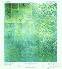
1970 Map of West Palm Beach 2 NW
USGS Topo · Published 1976About this map
The Corbett State Wildlife Management Area dominates this orthophotomosaic, showcasing the distinct transition between Florida’s managed conservation lands and expanding industrial infrastructure in the early 1970s. The map illustrates a landscape of patterned wetlands and hammocks, punctuated by the straight transit line of the Seaboard Coast Line railroad cutting across the northeastern corner. This specialized survey, created from aerial photography, provides an unusually clear view of early infrastructure like the Pump stations and Substation facilities that enabled the drainage and development of the surrounding terrain. To the south, the solitary landmark of Big Mound stands out against the low-lying wet prairie, offering a rare point of topographical relief in a region defined by its flat, intricate water patterns.
Find a feature on this map
7 named features on this map. Tap any name to fly to it.
Don’t see what you’re looking for? This feature index may not catch every label — zoom into the map to look around manually.
Map Details
Editions of this 1970 West Palm Beach 2 NW Map
3 editions found
Other maps of this area

1953 · Okeechobee 4 SE
USGS Topo · 1:24,000

1953 · Indian Town SE
USGS Topo · 1:24,000

1953 · Indian Town
USGS Topo · 1:24,000

1956 · West Palm Beach
USGS Topo · 1:250,000

1956 · Fort Pierce
USGS Topo · 1:250,000

1957 · West Palm Beach
USGS Topo · 1:250,000

1958 · Fort Pierce
USGS Topo · 1:250,000

1958 · West Palm Beach
USGS Topo · 1:250,000

1959 · Fort Pierce
USGS Topo · 1:250,000

1970 · West Palm Beach 2 SW
USGS Topo · 1:24,000