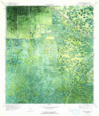
1970 Map of Big Mound North
USGS Topo · Published 1993About this map
Corbett State Wildlife Management Area dominates this orthophotomosaic, showing the intricate landscape of southern Florida's interior wetlands and prairies as they appeared in 1970. The transition from managed conservation land to agricultural and industrial development is clearly visible across the Martin Co Palm Beach Co line. In the northern reaches, a series of rectangular fields and a Pump station indicate early drainage and cultivation efforts adjacent to the marshy terrain. Infrastructure supporting the region's growth follows the Seaboard Coast Line railroad, which cuts diagonally through the landscape. Cultural and historical landmarks like Big Mound and Indian Mound provide important touchpoints for the area's ancient history, while a modern Substation and Water Tank mark the encroaching utilities of the late twentieth century.
Find a feature on this map
8 named features on this map. Tap any name to fly to it.
Don’t see what you’re looking for? This feature index may not catch every label — zoom into the map to look around manually.
Map Details
Editions of this 1970 Big Mound North Map
3 editions found
Other maps of this area

1953 · Okeechobee 4 SE
USGS Topo · 1:24,000

1953 · Indian Town SE
USGS Topo · 1:24,000

1953 · Indian Town
USGS Topo · 1:24,000

1956 · West Palm Beach
USGS Topo · 1:250,000

1956 · Fort Pierce
USGS Topo · 1:250,000

1957 · West Palm Beach
USGS Topo · 1:250,000

1958 · Fort Pierce
USGS Topo · 1:250,000

1958 · West Palm Beach
USGS Topo · 1:250,000

1959 · Fort Pierce
USGS Topo · 1:250,000

1970 · West Palm Beach 2 SW
USGS Topo · 1:24,000