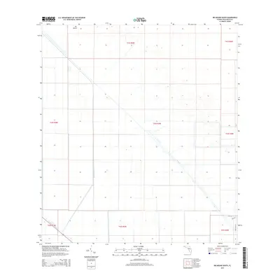
2015 Map of Big Mound South
USGS Topo · Published 2015About this map
Big Mound rises as a singular topographic feature in this western Palm Beach County landscape, where the primary character is defined by an extensive network of water management infrastructure. The mid-2010s survey shows the intersection of the Big Mound Canal and the diagonal course of the L-8 Canal, which cuts through the flat terrain to regulate water flow. To the south, the West Palm Beach Canal serves as a major arterial waterway, illustrating the engineering required to manage the wetlands and agricultural land of the northern Everglades region. The southeastern corner reveals a small pocket of rural development, marked by local roads like 59th Ln N and 208th Trl, contrasting with the large-scale grid of township and range sections that organize the surrounding territory.
Find a feature on this map
15 named features on this map. Tap any name to fly to it.
Don’t see what you’re looking for? This feature index may not catch every label — zoom into the map to look around manually.
Map Details
Editions of this 2015 Big Mound South Map
This is the sole edition of this map. No revisions or reprints were ever made.
Other maps of this area

1956 · West Palm Beach
USGS Topo · 1:250,000

1957 · West Palm Beach
USGS Topo · 1:250,000

1958 · West Palm Beach
USGS Topo · 1:250,000

1970 · West Palm Beach 2 SW
USGS Topo · 1:24,000

1970 · Loxahatchee NW
USGS Topo · 1:24,000
1970 · West Palm Beach 2 NE
USGS Topo · 1:24,000

1970 · Bryant
USGS Topo · 1:24,000

1970 · Sixmile Bend
USGS Topo · 1:24,000
1970 · West Palm Beach 2 NW
USGS Topo · 1:24,000
1971 · West Palm Beach 2 SE
USGS Topo · 1:24,000