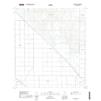
2018 Map of Big Mound South
USGS Topo · Published 2018About this map
Big Mound rises as a focal point in this portion of the northern Everglades, an area defined by the massive hydrological engineering projects of Palm Beach County. The landscape is dominated by the geometric precision of the Central and Southern Florida Flood Control Project, most notably the West Palm Beach Canal and the L-8 Canal. These waterways, along with the Big Mound Canal, illustrate the 20th-century effort to drain and manage the wetlands for agricultural and residential use.
Find a feature on this map
16 named features on this map. Tap any name to fly to it.
Don’t see what you’re looking for? This feature index may not catch every label — zoom into the map to look around manually.
Map Details
Editions of this 2018 Big Mound South Map
This is the sole edition of this map. No revisions or reprints were ever made.
Other maps of this area

1956 · West Palm Beach
USGS Topo · 1:250,000

1957 · West Palm Beach
USGS Topo · 1:250,000

1958 · West Palm Beach
USGS Topo · 1:250,000

1970 · West Palm Beach 2 SW
USGS Topo · 1:24,000

1970 · Loxahatchee NW
USGS Topo · 1:24,000
1970 · West Palm Beach 2 NE
USGS Topo · 1:24,000

1970 · Bryant
USGS Topo · 1:24,000

1970 · Sixmile Bend
USGS Topo · 1:24,000
1970 · West Palm Beach 2 NW
USGS Topo · 1:24,000
1971 · West Palm Beach 2 SE
USGS Topo · 1:24,000