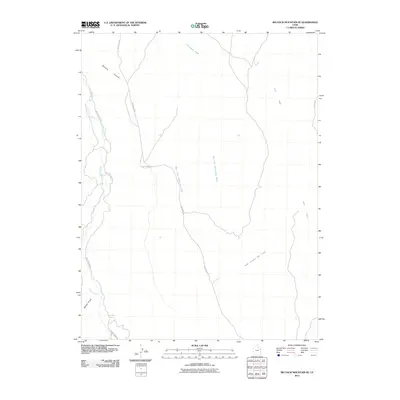
2011 Map of Big Pack Mountain SE
USGS Topo · Published 2011About this map
Buck Canyon Gas Field marks the center of industrial activity in this high-desert portion of Uintah County, where the landscape is defined by deep drainages and utility corridors. The map documents a complex system of watercourses, including the convergence of West Fork Cottonwood Wash and East Fork Cottonwood Wash as they transition into the main Cottonwood Wash. These natural features dictate the path of infrastructure, such as the prominent Seep Ridge Rd that snakes along the high ground between canyons. To the west, the course of Willow Creek provides a lower-elevation route followed by Willow Creek Rd, passing by Sulphur Spring. The cartography illustrates a modern era of resource extraction and rural transport, where named features like Broome Canyon and Agency Draw provide the only landmarks in an otherwise sparse, utilitarian environment.
Find a feature on this map
12 named features on this map. Tap any name to fly to it.
Don’t see what you’re looking for? This feature index may not catch every label — zoom into the map to look around manually.
Map Details
Editions of this 2011 Big Pack Mountain SE Map
This is the sole edition of this map. No revisions or reprints were ever made.
Other maps of this area

1885 · East Tavaputs
USGS Topo · 1:250,000

1956 · Grand Junction
USGS Topo · 1:250,000

1959 · Grand Junction
USGS Topo · 1:250,000

1960 · Grand Junction
USGS Topo · 1:250,000

1962 · Grand Junction
USGS Topo · 1:250,000

1964 · Grand Junction
USGS Topo · 1:250,000

1965 · Grand Junction
USGS Topo · 1:250,000

1966 · Bates Knolls
USGS Topo · 1:24,000
1966 · Agency Draw NE
USGS Topo · 1:24,000
1966 · Agency Draw NW
USGS Topo · 1:24,000