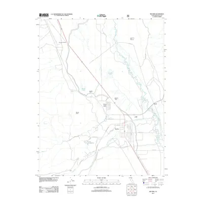
2012 Map of Big Pine
USGS Topo · Published 2012About this map
Big Pine stands as the primary hub of this eastern California landscape, where the valley floor meets the rising Sierra Nevada. The settlement pattern is defined by its proximity to vital water resources like Big Pine Creek and the Baker Creek drainage, which support local life at Inyo Camp and Owens Valley Ranch. To the north, the scientific significance of the region is marked by the Owens Valley Radio Observatory, a distinct landmark positioned in the wide valley expanse.
Find a feature on this map
34 named features on this map. Tap any name to fly to it.
Don’t see what you’re looking for? This feature index may not catch every label — zoom into the map to look around manually.
Map Details
Editions of this 2012 Big Pine Map
This is the sole edition of this map. No revisions or reprints were ever made.
Other maps of this area

1913 · Bishop
USGS Topo · 1:125,000

1947 · Mariposa
USGS Topo · 1:250,000

1948 · Mariposa
USGS Topo · 1:250,000

1949 · Bishop
USGS Topo · 1:62,500

1950 · Big Pine
USGS Topo · 1:62,500

1951 · Bishop
USGS Topo · 1:62,500

1951 · Blanco Mountain
USGS Topo · 1:62,500

1951 · Waucoba Mtn.
USGS Topo · 1:62,500

1957 · Mariposa
USGS Topo · 1:250,000
1958 · Waucoba Mtn
USGS Topo · 1:62,500