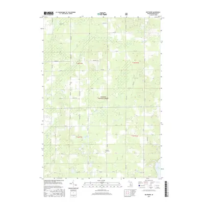
2017 Map of Big Prairie
USGS Topo · Published 2017About this map
The Manistee National Forest defines the central landscape of this Newaygo County region, where wooded tracts meet a complex network of wetlands and small water bodies. The geography is characterized by several named basins and marshes, including Harness Marsh, Gustafson Marsh, and Biddleman Marsh, which provide a distinct contrast to the upland forest areas. To the south, the waters of the Muskegon River back up into the Hardy Dam Pond, while smaller drainages like Fivemile Creek and Flinton Cr carve through the township. For those researching local heritage, the map identifies the Amish Cem and the Big Prairie- Everett Cem, reflecting the area's rural settlement patterns. The section lines of t14n r12w and adjacent townships overlay a grid of country roads, such as Vanburen Rd and Monroe Rd, that connect isolated farmsteads and natural landmarks like Eaves Lake and Fry Lake.
Find a feature on this map
62 named features on this map. Tap any name to fly to it.
Don’t see what you’re looking for? This feature index may not catch every label — zoom into the map to look around manually.
Map Details
Editions of this 2017 Big Prairie Map
This is the sole edition of this map. No revisions or reprints were ever made.
Other maps of this area

1954 · Midland
USGS Topo · 1:250,000

1958 · Midland
USGS Topo · 1:250,000

1958 · Sand Lake
USGS Topo · 1:62,500

1958 · Fremont
USGS Topo · 1:62,500

1958 · Woodville
USGS Topo · 1:62,500

1959 · Midland
USGS Topo · 1:250,000

1959 · White Cloud
USGS Topo · 1:62,500

1966 · Midland
USGS Topo · 1:250,000

1976 · White Cloud SE
USGS Topo · 1:24,000
1976 · White Cloud NE
USGS Topo · 1:24,000