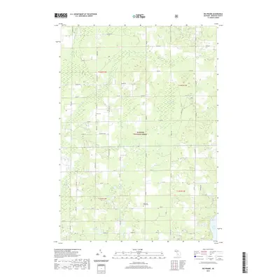
2019 Map of Big Prairie
USGS Topo · Published 2019About this map
The Manistee National Forest dominates this landscape in Newaygo County, where a complex network of wetlands and creeks defines the local geography. Significant marshlands including Harness Marsh, Gustafson Marsh, and Biddleman Marsh occupy the central and southern reaches, while Dudgeon Swamp lies to the northeast. These wet areas are drained by a series of small waterways like Fivemile Cr and Mullen Cr, eventually meeting the expansive waters of the Hardy Dam Pond at the southern edge. For those researching local heritage, the map identifies the Amish Cem and the Big Prairie-Everett Cem, which serve as quiet landmarks for the community's history. The intersection of woodland and small-scale agriculture is evident in the grid of roads such as Washington Rd and Monroe Rd that border the protected forest land.
Find a feature on this map
36 named features on this map. Tap any name to fly to it.
Don’t see what you’re looking for? This feature index may not catch every label — zoom into the map to look around manually.
Map Details
Editions of this 2019 Big Prairie Map
This is the sole edition of this map. No revisions or reprints were ever made.
Other maps of this area

1954 · Midland
USGS Topo · 1:250,000

1958 · Midland
USGS Topo · 1:250,000

1958 · Sand Lake
USGS Topo · 1:62,500

1958 · Fremont
USGS Topo · 1:62,500

1958 · Woodville
USGS Topo · 1:62,500

1959 · Midland
USGS Topo · 1:250,000

1959 · White Cloud
USGS Topo · 1:62,500

1966 · Midland
USGS Topo · 1:250,000

1976 · White Cloud SE
USGS Topo · 1:24,000
1976 · White Cloud NE
USGS Topo · 1:24,000