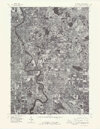
1976 Map of Big Rapids NW
USGS Topo · Published 1979About this map
Big Rapids serves as the primary urban center for this mid-1970s orthophotoquad, showing the city's western and northern layout during a period of significant regional stability. The dense residential grid and commercial plots of the town contrast sharply with the winding path of the Muskegon River, which dominates the western half of the landscape. Unlike traditional topographic maps, this aerial imagery provides a direct look at land usage, revealing the precise boundaries of woodlots, agricultural fields, and the developing outskirts of the city. To the east, the terrain transitions into a more rural character defined by smaller water bodies and open tracts, including the area around Clear Lake. The imagery, captured by the U.S. Geological Survey in May 1976, documents the exact footprint of the community before later decades of expansion and infrastructure changes shifted the local landscape.
Find a feature on this map
3 named features on this map. Tap any name to fly to it.
Don’t see what you’re looking for? This feature index may not catch every label — zoom into the map to look around manually.
Map Details
Editions of this 1976 Big Rapids NW Map
This is the sole edition of this map. No revisions or reprints were ever made.
Other maps of this area

1954 · Midland
USGS Topo · 1:250,000

1958 · Midland
USGS Topo · 1:250,000

1958 · Woodville
USGS Topo · 1:62,500

1958 · Big Rapids
USGS Topo · 1:62,500

1959 · Midland
USGS Topo · 1:250,000

1959 · Evart
USGS Topo · 1:62,500

1959 · Reed City
USGS Topo · 1:62,500

1966 · Midland
USGS Topo · 1:250,000

1976 · Big Rapids SE
USGS Topo · 1:24,000

1976 · Evart SW
USGS Topo · 1:24,000
Featured Places
- Big Rapids, MI
- Big Rapids Township, MI
- Austin Township, MI
- Mecosta Township, MI
- Green Charter Township, MI