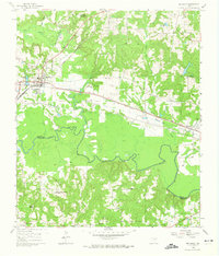
1960 Map of Big Sandy
USGS Topo · Published 1974About this map
The St Louis Southwestern and Texas and Pacific railroads intersect at Big Sandy, a vital transportation hub situated just north of the Sabine River on the border of Upshur and Smith counties. This mid-century survey illustrates a landscape of established rural communities and faith-based institutions, including the Seventh Day Adventist Camp and Camp Natowa (Camp Fire Girls) near Rocky Creek. The terrain transitions from the low-lying wetlands of Big Sandy Creek to the prominent height of Pinnacle Mountain in the north. Scattered throughout the countryside are local landmarks like the Excelsior Sch and Tabernacle, alongside numerous country churches such as Locust Grove Ch and Bethel Ch, which served as the social centers for the surrounding farming families and small settlements like Waters Bluff.
Find a feature on this map
25 named features on this map. Tap any name to fly to it.
Don’t see what you’re looking for? This feature index may not catch every label — zoom into the map to look around manually.
Map Details
Editions of this 1960 Big Sandy Map
Other maps of this area

1936 · Kilgore
USGS Topo · 1:48,000

1938 · Winona
USGS Topo · 1:48,000

1940 · Kilgore
USGS Topo · 1:62,500

1943 · Winona
USGS Topo · 1:62,500

1956 · Tyler
USGS Topo · 1:250,000

1960 · Shady Grove
USGS Topo · 1:24,000

1960 · Hawkins
USGS Topo · 1:24,000

1960 · Big Sandy
USGS Topo · 1:24,000

1960 · Pritchett
USGS Topo · 1:24,000

1960 · Gilmer
USGS Topo · 1:24,000