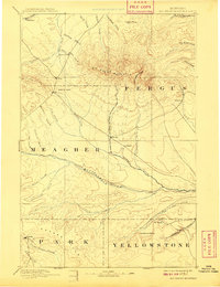
1893 Map of Big Snowy Mountain
USGS Topo · Published 1909About this map
Big Snowy Mountain dominates the central landscape of this 1880s-era survey, its radial drainage feeding numerous creeks that supported early cattle-range settlements. In this period before extensive rail development in the region, the map documents a network of isolated outposts such as Ubet, Bercail, and Filbrook. The geography is defined by significant natural landmarks like Half Moon Pass and the distinctive Locomotive Butte, which served as critical waypoints for travelers through the Judith Gap. South of the mountain, the Musselshell River meanders through the territory, flanked by the Cayuse Hills. The survey, conducted by E.M. Douglas for the Northern Transcontinental Survey, captures a frontier transition where county lines for Fergus, Meagher, Park, and Yellowstone met in a largely unsettled territory.
Find a feature on this map
46 named features on this map. Tap any name to fly to it.
Don’t see what you’re looking for? This feature index may not catch every label — zoom into the map to look around manually.
Map Details
Editions of this 1893 Big Snowy Mountain Map
4 editions found
Other maps of this area

1886 · Little Belt Mts.
USGS Topo · 1:250,000

1889 · Big Snowy Mountain
USGS Topo · 1:250,000

1890 · Fort Benton
USGS Topo · 1:250,000

1891 · Livingston
USGS Topo · 1:250,000

1891 · Big Timber
USGS Topo · 1:125,000

1892 · Fort Benton
USGS Topo · 1:250,000

1892 · Stillwater
USGS Topo · 1:125,000

1893 · Livingston
USGS Topo · 1:250,000

1893 · Big Snowy Mountain
USGS Topo · 1:250,000

1893 · Big Timber
USGS Topo · 1:125,000