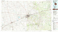
1954 Map of Big Spring
USGS Topo · Published 1965This historical map portrays the area of Big Spring in 1954, primarily covering Howard County as well as portions of Sterling County, Stonewall County, Glasscock County, Nolan County, Kent County, Borden County, Dawson County, Midland County, Runnels County, Taylor County, Mitchell County, Garza County, Lynn County, Martin County, Jones County, Fisher County, Coke County, and Scurry County. Featuring a scale of 1:250000, this map provides a highly detailed snapshot of the terrain, roads, buildings, counties, and historical landmarks in the Big Spring region at the time. Published in 1965, it is one of 4 known editions of this map due to revisions or reprints.
Find a feature on this map
153 named features on this map. Tap any name to fly to it.
Don’t see what you’re looking for? This feature index may not catch every label — zoom into the map to look around manually.
Map Details
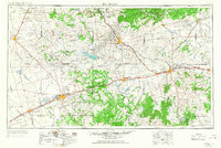
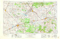
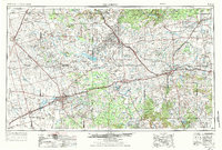
Editions of this 1954 Big Spring Map
4 editions found
Historical Maps of Dwight Through Time
3 maps found