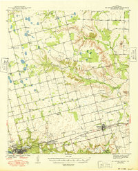
1971 Map of Big Spring North
USGS Topo · Published 1974About this map
Industrial development and agricultural settlement define the landscape in this Howard County quadrangle, where the Texas and Pacific railroad corridor serves as the primary axis for growth. In the southwest, Big Spring emerges as a regional hub, featuring a concentrated urban footprint with specialized facilities like the State Hospital, an Experiment Farm, and a prominent Radio Tower. To the east, the small communities of Coahoma and Sand Springs highlight the rail-dependent economy, while a nearby Refinery and Tank Farm indicate the area's emerging petroleum and processing infrastructure.
Find a feature on this map
39 named features on this map. Tap any name to fly to it.
Don’t see what you’re looking for? This feature index may not catch every label — zoom into the map to look around manually.
Map Details
Editions of this 1971 Big Spring North Map
This is the sole edition of this map. No revisions or reprints were ever made.
Other maps of this area

1941 · Morita
USGS Topo · 1:62,500

1941 · Big Spring South
USGS Topo · 1:62,500

1942 · Big Spring South
USGS Topo · 1:62,500

1942 · Big Spring North
USGS Topo · 1:62,500

1949 · Morita
USGS Topo · 1:62,500

1951 · Ira SW
USGS Topo · 1:24,000

1951 · Vincent
USGS Topo · 1:24,000

1951 · Iatan
USGS Topo · 1:24,000

1952 · Iatan
USGS Topo · 1:24,000

1954 · Big Spring
USGS Topo · 1:250,000