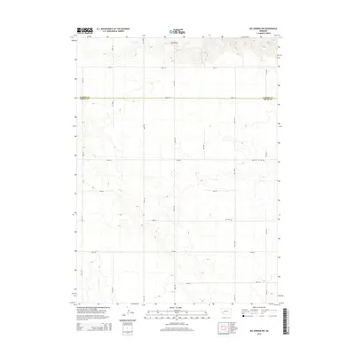
2014 Map of Big Springs NW
USGS Topo · Published 2014About this map
Ash Hollow dominates the northern reaches of this High Plains landscape, where the terrain breaks into a complex series of draws and ridges along the border of Garden Co and Deuel Co. This area of western Nebraska preserves a traditional grid of section-line roads, such as Road 34 and Road 195, which navigate the undulating topography of the tableland. The ephemeral drainage of Dry Cr cuts through the southwest, a reminder of the seasonal water patterns that have long dictated ranching and land use in this semi-arid environment.
Find a feature on this map
19 named features on this map. Tap any name to fly to it.
Don’t see what you’re looking for? This feature index may not catch every label — zoom into the map to look around manually.
Map Details
Editions of this 2014 Big Springs NW Map
This is the sole edition of this map. No revisions or reprints were ever made.
Other maps of this area

1900 · Chappell
USGS Topo · 1:125,000

1954 · Scottsbluff
USGS Topo · 1:250,000

1958 · Scottsbluff
USGS Topo · 1:250,000

1961 · Barton
USGS Topo · 1:24,000

1961 · Big Springs
USGS Topo · 1:24,000

1961 · Chappell SE
USGS Topo · 1:24,000
1971 · Big Springs NE
USGS Topo · 1:24,000
1971 · Ruthton
USGS Topo · 1:24,000

1971 · Barn Butte
USGS Topo · 1:24,000

1971 · Chappell NE
USGS Topo · 1:24,000