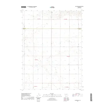
2017 Map of Big Springs NW
USGS Topo · Published 2017About this map
Ash Hollow dominates the northern bluffs of this 2017 survey, marking a significant break in the high plains topography of the Garden County and Deuel County border. The landscape is defined by the rigid geometry of the Public Land Survey System, with gravel roads like RD 34 and RD 199 tracing section lines across the plateau. In the southern half, the intermittent path of Dry Cr weaves through the draws, reflecting the seasonal water patterns of this high-altitude prairie. For family historians, the presence of Zion Cem and Day Cem provides essential spatial context for the rural communities that have long farmed these sections. The map reveals the persistent grid of early Nebraska settlement, where the township boundaries of t14n r42w and its neighbors continue to organize the agricultural life of the region.
Find a feature on this map
24 named features on this map. Tap any name to fly to it.
Don’t see what you’re looking for? This feature index may not catch every label — zoom into the map to look around manually.
Map Details
Editions of this 2017 Big Springs NW Map
This is the sole edition of this map. No revisions or reprints were ever made.
Other maps of this area

1900 · Chappell
USGS Topo · 1:125,000

1954 · Scottsbluff
USGS Topo · 1:250,000

1958 · Scottsbluff
USGS Topo · 1:250,000

1961 · Barton
USGS Topo · 1:24,000

1961 · Big Springs
USGS Topo · 1:24,000

1961 · Chappell SE
USGS Topo · 1:24,000
1971 · Big Springs NE
USGS Topo · 1:24,000
1971 · Ruthton
USGS Topo · 1:24,000

1971 · Barn Butte
USGS Topo · 1:24,000

1971 · Chappell NE
USGS Topo · 1:24,000