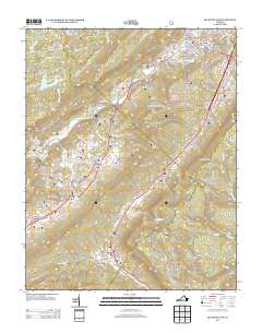
2013 Map of Big Stone Gap
USGS Topo · Published 2013About this map
Big Stone Gap serves as the central hub of this Appalachian landscape, where the Powell River and S Fork Powell River converge. The town's layout is intricately detailed, showing the Hugh Williams Memorial Bridge and neighborhood sectors like Beamantown and Cadet. The surrounding terrain is defined by the massive spine of Stone Mountain and a series of deep hollows and ridges that dictated the path of early settlement and industry, including the mining-associated name Irondale.
Find a feature on this map
105 named features on this map. Tap any name to fly to it.
Don’t see what you’re looking for? This feature index may not catch every label — zoom into the map to look around manually.
Map Details
Editions of this 2013 Big Stone Gap Map
This is the sole edition of this map. No revisions or reprints were ever made.
Other maps of this area

1894 · Estillville
USGS Topo · 1:125,000

1920 · Wise
USGS Topo · 1:48,000

1921 · Big Stone Gap
USGS Topo · 1:48,000

1921 · Wise
USGS Topo · 1:62,500

1922 · Big Stone Gap
USGS Topo · 1:62,500

1929 · Big Stone Gap
USGS Topo · 1:62,500

1935 · Moggasin
USGS Topo · 1:48,000
1935 · Norton
USGS Topo · 1:24,000
1935 · Appalachia
USGS Topo · 1:24,000

1935 · East Stone Gap
USGS Topo · 1:24,000