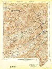
1929 Map of Big Stone Gap
USGS Topo · Published 1942About this map
Big Stone Gap sits at the convergence of the Powell River and South Fork at the base of Little Stone Mountain, serving as a central hub in this 1920s Appalachian landscape. The terrain is defined by the massive spine of Black Mountain and Stone Mountain, where narrow hollows like Possum Trot Hollow and Roaring Fork house industrial coal settlements and rail spurs. The Southern Ry and Louisville & Nashville R R wind through these gaps, connecting towns such as Appalachia, Stonega, and Lynch. Local life in the early 20th century is evident through the scattered rural infrastructure, including Johnsons Mill P O, Robbins Chapel, and schools like the Seminary School and Blair School. These details reveal a society organized around both the river valleys and the resource-rich ridges during a period of intense mining and rail development.
Find a feature on this map
97 named features on this map. Tap any name to fly to it.
Don’t see what you’re looking for? This feature index may not catch every label — zoom into the map to look around manually.
Map Details
Editions of this 1929 Big Stone Gap Map
3 editions found

Other maps of this area

1887 · Jonesville
USGS Topo · 1:125,000

1890 · Whitesburg
USGS Topo · 1:125,000

1891 · Hazard
USGS Topo · 1:125,000

1891 · Jonesville
USGS Topo · 1:125,000

1892 · Whitesburg
USGS Topo · 1:125,000

1894 · Estillville
USGS Topo · 1:125,000

1912 · Pound
USGS Topo · 1:48,000

1913 · Oven Fork
USGS Topo · 1:48,000

1914 · Pound
USGS Topo · 1:62,500

1915 · Whitesburg
USGS Topo · 1:62,500