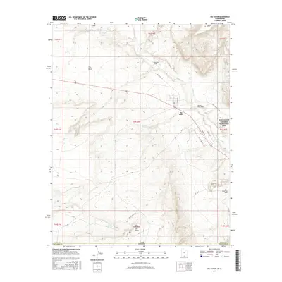
2017 Map of Big Water
USGS Topo · Published 2017About this map
Big Water sits at the heart of this high-desert landscape near the Utah-Arizona border, surrounded by complex drainages and plateau formations. The settlement is defined by its distinct street names, including Victory Way, Freedom Way, and Independence, while serving as a gateway to the Glen Canyon National Recreation Area to the east. The terrain is marked by seasonal watercourses like Wahweap Cr and Chitum Wash, which carve through the high ground of the East Clark Bench and Cedar Mtn.
Find a feature on this map
42 named features on this map. Tap any name to fly to it.
Don’t see what you’re looking for? This feature index may not catch every label — zoom into the map to look around manually.
Map Details
Editions of this 2017 Big Water Map
This is the sole edition of this map. No revisions or reprints were ever made.
Other maps of this area

1886 · Escalante
USGS Topo · 1:250,000

1886 · Echo Cliffs
USGS Topo · 1:250,000

1891 · Echo Cliffs
USGS Topo · 1:250,000

1951 · Lees Ferry NE
USGS Topo · 1:24,000

1953 · Nipple Butte
USGS Topo · 1:62,500

1954 · Lees Ferry NW
USGS Topo · 1:24,000

1954 · Lees Ferry
USGS Topo · 1:62,500
1954 · Paria Plateau
USGS Topo · 1:62,500

1954 · Paria
USGS Topo · 1:62,500

1956 · Escalante
USGS Topo · 1:250,000