
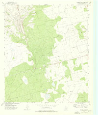
1973 Map of Bigby Corner
USGS Topo · Published 1976About this map
Oil Field infrastructure dominates the West Texas landscape across the border of Glasscock and Reagan Counties. The survey, field checked in the early 1970s, illustrates a highly organized grid of pipelines and wells surrounding the small settlement at Bigby. The terrain is punctuated by significant industrial and transportation markers, including the Bigby Corner benchmark and a Landing Strip to the southeast. Natural hydrology is represented by the presence of Hackberry Lake in the northern reaches, though much of the land's utility is clearly focused on extraction and utility. The inclusion of several Gravel Pits and the Sub Sta further reflects a region shaped by industrial support systems and energy development.
Find a feature on this map
8 named features on this map. Tap any name to fly to it.
Don’t see what you’re looking for? This feature index may not catch every label — zoom into the map to look around manually.
Map Details
Editions of this 1973 Bigby Corner Map
This is the sole edition of this map. No revisions or reprints were ever made.
Other maps of this area

1954 · San Angelo
USGS Topo · 1:250,000

1958 · San Angelo
USGS Topo · 1:250,000

1965 · San Angelo
USGS Topo · 1:250,000

1965 · Dewey Lake SE
USGS Topo · 1:24,000

1965 · Pecks Lake
USGS Topo · 1:24,000

1965 · Patterson Lake
USGS Topo · 1:24,000

1967 · Midkiff
USGS Topo · 1:24,000

1968 · Midkiff SE
USGS Topo · 1:24,000

1973 · Saint Lawrence SE
USGS Topo · 1:24,000
1973 · Slager Lake
USGS Topo · 1:24,000