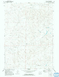
1970 Map of Bill 4 SW
USGS Topo · Published 1991About this map
Werner Ranch sits as a primary point of human activity within this 1970 landscape of eastern Wyoming. The terrain is defined by a dendritic network of seasonal waterways and intermittent drainages, most notably Lightning Creek, which meanders through the central and southern portions of the quadrangle. Several instances of a Flowing Well are marked across the sheet, indicating the critical importance of managed water sources for livestock and ranching in this arid region of Converse County. The drainage patterns of Box Creek, Willow Creek, and Mikes Draw illustrate the natural topography that dictated land use and property boundaries between township lines T. 35 N. and T. 36 N. during this era of western ranching history.
Find a feature on this map
7 named features on this map. Tap any name to fly to it.
Don’t see what you’re looking for? This feature index may not catch every label — zoom into the map to look around manually.
Map Details
Editions of this 1970 Bill 4 SW Map
3 editions found
Other maps of this area

1949 · Clausen Ranch
USGS Topo · 1:24,000

1950 · Clausen Ranch
USGS Topo · 1:24,000

1954 · Torrington
USGS Topo · 1:250,000

1955 · Newcastle
USGS Topo · 1:250,000

1958 · Torrington
USGS Topo · 1:250,000

1958 · Newcastle
USGS Topo · 1:250,000

1959 · Bill
USGS Topo · 1:62,500

1970 · Bill 4 SE
USGS Topo · 1:24,000

1970 · Walker Creek School
USGS Topo · 1:24,000

1970 · Bill 4 NW
USGS Topo · 1:24,000