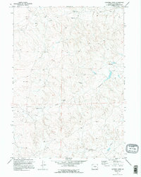
1970 Map of Lightning Creek
USGS Topo · Published 1995About this map
Werner Ranch stands as a focal point of human settlement in this high plains landscape of Converse County, documented during a 1970 field check. The terrain is defined by an intricate network of drainage systems, most notably the winding course of Lightning Creek, which is joined by Box Creek and Willow Creek as they cut through the dry rangeland. Strategic water access in this arid environment is highlighted by the presence of several Flowing Wells and the prominent Box Draw. This survey captures the rural character of the area just as aerial photography was becoming a primary tool for mapping the American West, showing the precise township boundaries of T. 36 N. and T. 35 N. that organized the open range into manageable tracts for ranching and resource management.
Find a feature on this map
7 named features on this map. Tap any name to fly to it.
Don’t see what you’re looking for? This feature index may not catch every label — zoom into the map to look around manually.
Map Details
Editions of this 1970 Lightning Creek Map
3 editions found
Other maps of this area

1949 · Clausen Ranch
USGS Topo · 1:24,000

1950 · Clausen Ranch
USGS Topo · 1:24,000

1954 · Torrington
USGS Topo · 1:250,000

1955 · Newcastle
USGS Topo · 1:250,000

1958 · Torrington
USGS Topo · 1:250,000

1958 · Newcastle
USGS Topo · 1:250,000

1959 · Bill
USGS Topo · 1:62,500

1970 · Bill 4 SE
USGS Topo · 1:24,000

1970 · Walker Creek School
USGS Topo · 1:24,000

1970 · Bill 4 NW
USGS Topo · 1:24,000