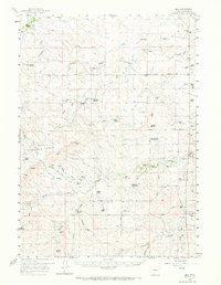
1959 Map of Bill
USGS Topo · Published 1972About this map
Water management and cattle ranching define this high plains landscape in Converse County, where dozens of named water features like Artesian Well, Anderson Reservoir, and Fiddleback Reservoir support a network of established homesteads. The map documents a community built around isolated outposts such as Tillard Ranch, Ireton Ranch, and Johnson Ranch, interconnected by the Tillard Road and Highland Loop Road.
Find a feature on this map
50 named features on this map. Tap any name to fly to it.
Don’t see what you’re looking for? This feature index may not catch every label — zoom into the map to look around manually.
Map Details
Editions of this 1959 Bill Map
2 editions found

Other maps of this area

1949 · Sundquist Ranch
USGS Topo · 1:24,000

1949 · Gilbert Lake
USGS Topo · 1:24,000

1949 · Clausen Ranch
USGS Topo · 1:24,000

1950 · Clausen Ranch
USGS Topo · 1:24,000

1950 · Gilbert Lake
USGS Topo · 1:24,000
1950 · Sundquist Ranch
USGS Topo · 1:24,000

1954 · Torrington
USGS Topo · 1:250,000

1955 · Newcastle
USGS Topo · 1:250,000

1958 · Torrington
USGS Topo · 1:250,000

1958 · Newcastle
USGS Topo · 1:250,000