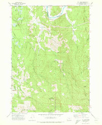
1971 Map of Bill Peak
USGS Topo · Published 1973About this map
Coquille River flows through the northern reaches of this coastal Oregon landscape, marking a transition between the river lowlands and the timbered heights of Bill Peak. The 1971 survey captures the agricultural and recreational footprint of the region near Winterville, where Cranberry Bogs dot the drainage of Geiger Creek. This period reveals a landscape organized by both water and terrain, where a Ferry still connects routes across the river bend while a network of paths like Fishrap Trail and Pack Trail penetrate the interior hills. The mapping of the Bandon Gun Club and various wells and water tanks suggests the localized development of the era. The intricate creek systems, including Lampa Creek and Hall Creek, define the topography, illustrating how early roads like Morrison Road and Randleman Creek Road were forced to navigate the sharp ridges and deep draws of the Coos County backcountry.
Find a feature on this map
38 named features on this map. Tap any name to fly to it.
Don’t see what you’re looking for? This feature index may not catch every label — zoom into the map to look around manually.
Map Details
Editions of this 1971 Bill Peak Map
2 editions found
Other maps of this area

1896 · Coos Bay
USGS Topo · 1:125,000

1898 · Coos Bay
USGS Topo · 1:125,000

1899 · Port Orford
USGS Topo · 1:125,000

1900 · Coos Bay
USGS Topo · 1:125,000

1903 · Port Orford
USGS Topo · 1:125,000

1942 · Coquille
USGS Topo · 1:62,500

1943 · Bandon
USGS Topo · 1:62,500

1944 · Bandon
USGS Topo · 1:62,500

1945 · Coquille
USGS Topo · 1:62,500

1954 · Coos Bay
USGS Topo · 1:250,000