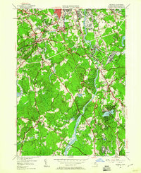
1950 Map of Billerica
USGS Topo · Published 1960About this map
The Concord River carves a winding path through this mid-century landscape, linking the industrial fringes of South Lowell with the expanding residential clusters of Billerica and Chelmsford Center. The geography is defined by a transition from traditional mill-and-rail infrastructure to modern institutional footprints, visible in the presence of the House of Correction and the extensive U S Veterans Hospital grounds near Bedford Springs. Significant local history is preserved in the numerous burial grounds, including the Edson Cem and St Joseph Cem, which sit alongside the Boston and Maine RR corridors.
Find a feature on this map
72 named features on this map. Tap any name to fly to it.
Don’t see what you’re looking for? This feature index may not catch every label — zoom into the map to look around manually.
Map Details
Editions of this 1950 Billerica Map
4 editions found
Other maps of this area

1886 · Lawrence
USGS Topo · 1:62,500

1886 · Lowell
USGS Topo · 1:62,500

1886 · Framingham
USGS Topo · 1:62,500

1888 · Lawrence
USGS Topo · 1:62,500

1889 · Framingham
USGS Topo · 1:62,500

1893 · Lowell
USGS Topo · 1:62,500

1893 · Boston
USGS Topo · 1:62,500

1893 · Lawrence
USGS Topo · 1:62,500

1894 · Framingham
USGS Topo · 1:62,500

1903 · Boston
USGS Topo · 1:62,500