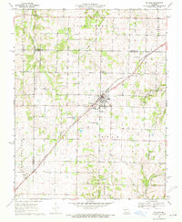
1969 Map of Billings
USGS Topo · Published 1971About this map
Billings serves as the central hub of this Missouri landscape, where the St Louis - San Francisco railroad cuts diagonally across the terrain. The map captures the agricultural and community fabric of the late 1960s, defined by a high density of rural cemeteries and small chapels such as Blades Chapel and Curtis Chapel that speak to the area's deep-rooted settlement history. To the southwest, the Missouri Pacific rail line passes through Logan and near the edge of Marionville, illustrating the vital role of rail transport in connecting these prairie communities.
Find a feature on this map
27 named features on this map. Tap any name to fly to it.
Don’t see what you’re looking for? This feature index may not catch every label — zoom into the map to look around manually.
Map Details
Editions of this 1969 Billings Map
2 editions found
Other maps of this area

1884 · Springfield
USGS Topo · 1:125,000

1886 · Greenfield
USGS Topo · 1:125,000

1886 · Springfield
USGS Topo · 1:125,000

1888 · Greenfield
USGS Topo · 1:125,000

1907 · Forsyth
USGS Topo · 1:125,000

1919 · Halltown
USGS Topo · 1:62,500

1936 · Brookline
USGS Topo · 1:24,000

1942 · Aurora
USGS Topo · 1:62,500

1945 · Harrison
USGS Topo · 1:250,000

1945 · Aurora
USGS Topo · 1:62,500