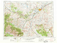
1954 Map of Billings
USGS Topo · Published 1963About this map
The Yellowstone River corridor serves as the primary axis of development across this mid-century landscape, anchoring the growing city of Billings and smaller rail towns like Laurel and Columbus. To the south, the dramatic transition from the high plains to the Beartooth Mountains is marked by mining and ranching settlements such as Red Lodge, Washoe, and Bearcreek. The map reveals a specialized economic landscape where oil wells and an extensive oil and gas field are interspersed with irrigation-supported agriculture along the Clarks Fork Yellowstone River.
Find a feature on this map
154 named features on this map. Tap any name to fly to it.
Don’t see what you’re looking for? This feature index may not catch every label — zoom into the map to look around manually.
Map Details
Editions of this 1954 Billings Map
4 editions found

Other maps of this area

1886 · Canyon
USGS Topo · 1:125,000

1886 · Little Belt Mts.
USGS Topo · 1:250,000

1889 · Big Snowy Mountain
USGS Topo · 1:250,000

1891 · Livingston
USGS Topo · 1:250,000

1891 · Big Timber
USGS Topo · 1:125,000

1892 · Stillwater
USGS Topo · 1:125,000

1893 · Livingston
USGS Topo · 1:250,000

1893 · Big Snowy Mountain
USGS Topo · 1:250,000

1893 · Big Timber
USGS Topo · 1:125,000

1893 · Huntley
USGS Topo · 1:125,000