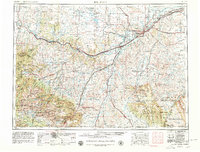
1954 Map of Billings
USGS Topo · Published 1980About this map
The Yellowstone River serves as the central artery for this mid-century look at South Central Montana, where the rail-and-river economy transitions into the high peaks of the Beartooth Mountains. The northern reaches of Yellowstone National Park and the sprawling Crow Indian Reservation dominate the southern landscape, reflecting a region defined by federal land management and tribal sovereignty. To the north, the Northern Pacific railroad connects industrial and agricultural hubs like Billings, Laurel, and Columbus. The map captures the rugged approach to the Absaroka Range and highlights the importance of mountain mining and ranching settlements such as Red Lodge, Bearcreek, and Cooke City. This survey illustrates the convergence of major transportation corridors, including U S 10 and U S 212, which were essential for both regional commerce and the burgeoning tourism surrounding the national forests.
Find a feature on this map
63 named features on this map. Tap any name to fly to it.
Don’t see what you’re looking for? This feature index may not catch every label — zoom into the map to look around manually.
Map Details
Editions of this 1954 Billings Map
4 editions found

Other maps of this area

1886 · Canyon
USGS Topo · 1:125,000

1886 · Little Belt Mts.
USGS Topo · 1:250,000

1889 · Big Snowy Mountain
USGS Topo · 1:250,000

1891 · Livingston
USGS Topo · 1:250,000

1891 · Big Timber
USGS Topo · 1:125,000

1892 · Stillwater
USGS Topo · 1:125,000

1893 · Livingston
USGS Topo · 1:250,000

1893 · Big Snowy Mountain
USGS Topo · 1:250,000

1893 · Big Timber
USGS Topo · 1:125,000

1893 · Huntley
USGS Topo · 1:125,000