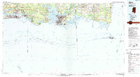
1982 Map of Biloxi
USGS Topo · Published 1982About this map
The Gulf Coast's intricate relationship between land and water is clearly visible in this early 1980s look at the Mississippi-Alabama shoreline. Centered on the industrial and military hubs of Biloxi and Pascagoula, the map reveals the extensive wetlands and protected habitats like the Mississippi Sandhill Crane National Wildlife Refuge and Breton National Wildlife Refuge. The transportation corridor is anchored by the Louisville & Nashville RR and the I-10 interstate, which bypasses older coastal settlements like Ocean Springs and Gautier.
Find a feature on this map
66 named features on this map. Tap any name to fly to it.
Don’t see what you’re looking for? This feature index may not catch every label — zoom into the map to look around manually.
Map Details
Editions of this 1982 Biloxi Map
2 editions found
Other maps of this area

1893 · Cat Island
USGS Topo · 1:62,500

1893 · Chandeleur
USGS Topo · 1:62,500

1921 · Grand Bay
USGS Topo · 1:62,500

1921 · Petit Bois Island
USGS Topo · 1:62,500

1921 · Point Clear
USGS Topo · 1:62,500

1921 · Fairhope
USGS Topo · 1:62,500

1921 · Dauphin Island
USGS Topo · 1:62,500

1921 · Delchamps
USGS Topo · 1:62,500

1922 · Mobile
USGS Topo · 1:62,500

1939 · Daphne
USGS Topo · 1:31,680