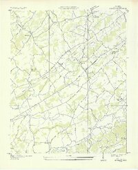
1935 Map of Binfield
USGS Topo · Published 1935About this map
Clover Hill and the surrounding Blount County landscape appear in this mid-1930s survey, characterized by a dense network of rural community centers and small-scale infrastructure. The presence of Brick Mill and Carpenter Camp Ground suggests a region where agriculture and local gathering places formed the backbone of social life. Transportation is defined by the Louisville and Nashville Railroad cutting diagonally through the terrain, alongside early road developments like State Highway No 33.
Find a feature on this map
43 named features on this map. Tap any name to fly to it.
Don’t see what you’re looking for? This feature index may not catch every label — zoom into the map to look around manually.
Map Details
Editions of this 1935 Binfield Map
2 editions found
Other maps of this area

1886 · Knoxville
USGS Topo · 1:125,000

1892 · Knoxville
USGS Topo · 1:125,000

1894 · Knoxville
USGS Topo · 1:125,000

1895 · Loudon
USGS Topo · 1:125,000

1895 · Knoxville
USGS Topo · 1:125,000

1901 · Knoxville
USGS Topo · 1:125,000

1935 · Binfield
USGS Topo · 1:24,000

1935 · Knoxville
USGS Topo · 1:48,000

1935 · Meadow
USGS Topo · 1:24,000

1935 · Maryville
USGS Topo · 1:24,000