
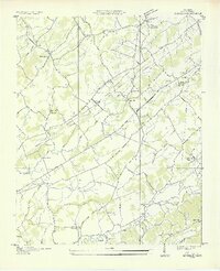
1935 Map of Binfield
USGS Topo · Published 1935About this map
The Louisville and Nashville Railroad cuts a diagonal path through this 1930s landscape, serving as the primary corridor for the communities of Binfield and Clover Hill. This area of Blount County is defined by its numerous rural congregations and educational hubs, such as Salem Ch, Laurel Bank Ch, and Rush Strong Sch. The Little Tennessee River flows along the southern edge, spanned by Henry Bridge and Reagan Bridge, reflecting the local infrastructure before modern developments changed the river's course. Local industry and social life are anchored at Brick Mill and the Carpenter Camp Ground. Topographically, the land transitions from the flats near Baker Creek to the rise of Hutton Ridge, with small family-named landmarks like Christie Hill and Hamil Cem providing valuable points of reference for genealogists.
Find a feature on this map
48 named features on this map. Tap any name to fly to it.
Don’t see what you’re looking for? This feature index may not catch every label — zoom into the map to look around manually.
Map Details
Editions of this 1935 Binfield Map
2 editions found
Other maps of this area

1886 · Knoxville
USGS Topo · 1:125,000

1892 · Knoxville
USGS Topo · 1:125,000

1894 · Knoxville
USGS Topo · 1:125,000

1895 · Loudon
USGS Topo · 1:125,000

1895 · Knoxville
USGS Topo · 1:125,000

1901 · Knoxville
USGS Topo · 1:125,000

1935 · Knoxville
USGS Topo · 1:48,000

1935 · Meadow
USGS Topo · 1:24,000

1935 · Maryville
USGS Topo · 1:24,000

1935 · Calderwood
USGS Topo · 1:24,000