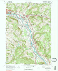
1968 Map of Binghamton East
USGS Topo · Published 1976About this map
The Susquehanna River snakes through the heart of this Broome County landscape, dictating the development of transport and settlement in the late 1960s. Along its eastern bank, the Erie-Lackawanna railroad tracks parallel the water, connecting a string of valley communities from Fivemile Point down to Riverside. On the northern edge, the expansive grounds of the State Hospital overlook the bend in the river near Binghamton, while educational and religious anchors like Susquehanna Valley High Sch and St Marys Ch serve the growing residential clusters. The terrain rises sharply away from the river into the wooded uplands of Conklin and Kirkwood, where family-named roads like Edwards Rd and Carlin Road wind past numerous small quarries and the quiet flow of Carlin Creek. This survey captures the transition from the industrial valley floor to the rural ridges before the further expansion of suburban infrastructure.
Find a feature on this map
79 named features on this map. Tap any name to fly to it.
Don’t see what you’re looking for? This feature index may not catch every label — zoom into the map to look around manually.
Map Details
Editions of this 1968 Binghamton East Map
2 editions found
Other maps of this area

1904 · Binghamton
USGS Topo · 1:62,500

1905 · Nineveh
USGS Topo · 1:62,500

1932 · Susquehanna
USGS Topo · 1:62,500

1934 · Castle Creek
USGS Topo · 1:24,000

1935 · Binghamton West
USGS Topo · 1:24,000

1935 · Chenango Forks
USGS Topo · 1:24,000

1935 · Susquehanna
USGS Topo · 1:62,500

1937 · Binghamton East
USGS Topo · 1:24,000

1942 · Binghamton West
USGS Topo · 1:31,680

1942 · Castle Creek
USGS Topo · 1:31,680