
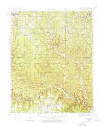
1944 Map of Birch Tree
USGS Topo · Published 1962About this map
Birch Tree and the surrounding Ozark landscapes are defined by an intricate network of springs and timber-heavy terrain as they appeared in the 1930s and 1940s. The northern reaches show the St Louis and San Francisco RR (Abandoned), a former artery for the region's logging industry, while the south is anchored by the Eleven Point River. Deep in the forest, the Black Pond State Game Refuge and numerous lookouts like Possum Trot Lookout emphasize the area's conservation and fire-monitoring history.
Find a feature on this map
87 named features on this map. Tap any name to fly to it.
Don’t see what you’re looking for? This feature index may not catch every label — zoom into the map to look around manually.
Map Details
Editions of this 1944 Birch Tree Map
2 editions found
Other maps of this area

1915 · Eminence
USGS Topo · 1:62,500

1917 · Eminence
USGS Topo · 1:62,500

1928 · Cardareva
USGS Topo · 1:62,500

1931 · Bandyville
USGS Topo · 1:48,000

1941 · Gatewood
USGS Topo · 1:62,500

1943 · Thayer
USGS Topo · 1:62,500

1944 · Van Buren
USGS Topo · 1:62,500

1944 · Couch
USGS Topo · 1:62,500

1945 · Gatewood
USGS Topo · 1:62,500

1945 · Montier
USGS Topo · 1:62,500