
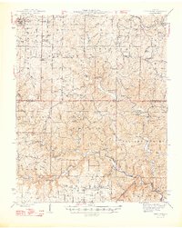
1948 Map of Birch Tree
USGS Topo · Published 1948About this map
Winona State Forest and the Eleven Point Refuge dominate this late 1940s landscape, illustrating a region defined by conservation and forest management. The geography is characterized by its karst features, including numerous sinks and springs such as Tupelo Gum Pond, Falling Spring, and the massive Greer Spring feeding the Eleven Point River. Rural life is centered around community landmarks like Blackjack Ch, Oak Grove Sch, and the Oak Forest Cem, serving the scattered residents of the Bartlett Ridge and Piedmont Ridge areas.
Find a feature on this map
64 named features on this map. Tap any name to fly to it.
Don’t see what you’re looking for? This feature index may not catch every label — zoom into the map to look around manually.
Map Details
Editions of this 1948 Birch Tree Map
2 editions found
Other maps of this area

1915 · Eminence
USGS Topo · 1:62,500

1917 · Eminence
USGS Topo · 1:62,500

1928 · Cardareva
USGS Topo · 1:62,500

1931 · Bandyville
USGS Topo · 1:48,000

1941 · Gatewood
USGS Topo · 1:62,500

1943 · Thayer
USGS Topo · 1:62,500

1944 · Van Buren
USGS Topo · 1:62,500

1944 · Couch
USGS Topo · 1:62,500

1944 · Birch Tree
USGS Topo · 1:62,500

1945 · Gatewood
USGS Topo · 1:62,500