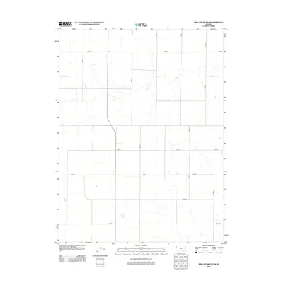
2012 Map of Bird City South SW
USGS Topo · Published 2012About this map
Little Beaver Cr meanders across the northern reaches of this High Plains landscape in Sherman County, providing the primary hydrological relief in an area defined by a strict section-line grid. This grid is composed of local routes such as Road D, Road 18, and Co Line Rd, reflecting the highly organized land division common in western Kansas. The map shows a landscape dominated by agricultural planning, where the intersection of Road 79 and Road 21 marks the quiet heart of the rural countryside. Genealogists and local historians can use the precise placement of these roads, including Road 76 and Road 77, to pinpoint family farmsteads and the evolution of rural infrastructure in the early 21st century.
Find a feature on this map
14 named features on this map. Tap any name to fly to it.
Don’t see what you’re looking for? This feature index may not catch every label — zoom into the map to look around manually.
Map Details
Editions of this 2012 Bird City South SW Map
This is the sole edition of this map. No revisions or reprints were ever made.
Other maps of this area

1951 · Bird City South
USGS Topo · 1:62,500

1952 · St Francis 3
USGS Topo · 1:62,500

1954 · Goodland
USGS Topo · 1:250,000

1956 · Goodland
USGS Topo · 1:250,000

1957 · Goodland
USGS Topo · 1:250,000

1966 · Goodland NW
USGS Topo · 1:24,000

1966 · Ruleton NE
USGS Topo · 1:24,000

1966 · Goodland NE
USGS Topo · 1:24,000
1978 · St. Francis 3 SE
USGS Topo · 1:24,000
1978 · Drury Creek
USGS Topo · 1:24,000