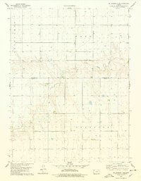
1978 Map of St. Francis 3 SE
USGS Topo · Published 1978About this map
Little Beaver Creek carves a distinct, winding path across the northern reaches of this high plains landscape, defining the topography of a region divided by the Cheyenne Co Sherman Co line. In the late 1970s, this area of Northwest Kansas was primarily organized into large administrative townships including Benkelman, Wano, Voltaire, and Grant. The map reveals a rural economy dependent on subterranean resources, evidenced by the numerous wells scattered across the grid and a specific Sandpit located near the creek bed. The stark geometry of the section lines contrasts with the complex drainage patterns of the creek, illustrating the intersection of late-20th-century land management and the natural hydrology of the plains.
Find a feature on this map
8 named features on this map. Tap any name to fly to it.
Don’t see what you’re looking for? This feature index may not catch every label — zoom into the map to look around manually.
Map Details
Editions of this 1978 St. Francis 3 SE Map
2 editions found
Other maps of this area

1951 · Bird City South
USGS Topo · 1:62,500

1952 · St Francis 3
USGS Topo · 1:62,500

1954 · Goodland
USGS Topo · 1:250,000

1956 · Goodland
USGS Topo · 1:250,000

1957 · Goodland
USGS Topo · 1:250,000

1966 · Goodland NW
USGS Topo · 1:24,000

1966 · Ruleton NW
USGS Topo · 1:24,000

1966 · Ruleton NE
USGS Topo · 1:24,000
1978 · Crosby Creek
USGS Topo · 1:24,000
1978 · Drury Creek
USGS Topo · 1:24,000