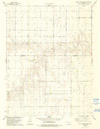
1978 Map of South of Drury Creek
USGS Topo · Published 1993About this map
Little Beaver Creek meanders through the central portion of this High Plains landscape, cutting a distinct valley through the townships of Benkelman, Wano, Grant, and Voltaire. Surveyed in the mid-1970s, the terrain is defined by its agricultural and resource-based character, notably marked by the Cheyenne Co Sherman Co boundary line. A single Sandpit along the creek and numerous Well sites scattered across the sections indicate the industrial activity of the era, while the section-line roads establish a rigid grid over the undulating topography. The map captures a moment in western Kansas history before significant modern developments, showing the persistent rural structure of the land and its reliance on local water sources and mineral extraction.
Find a feature on this map
8 named features on this map. Tap any name to fly to it.
Don’t see what you’re looking for? This feature index may not catch every label — zoom into the map to look around manually.
Map Details
Editions of this 1978 South of Drury Creek Map
2 editions found
Other maps of this area

1951 · Bird City South
USGS Topo · 1:62,500

1952 · St Francis 3
USGS Topo · 1:62,500

1954 · Goodland
USGS Topo · 1:250,000

1956 · Goodland
USGS Topo · 1:250,000

1957 · Goodland
USGS Topo · 1:250,000

1966 · Goodland NW
USGS Topo · 1:24,000

1966 · Ruleton NW
USGS Topo · 1:24,000

1966 · Ruleton NE
USGS Topo · 1:24,000
1978 · Crosby Creek
USGS Topo · 1:24,000
1978 · St. Francis 3 SE
USGS Topo · 1:24,000