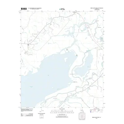
2012 Map of Bird Island Point
USGS Topo · Published 2012About this map
Catahoula Lake dominates the southern landscape of this 2012 survey, revealing a complex hydrological system of bayous and wetlands at the edge of the Catahoula National Wildlife Re Re. The drainage patterns of the Little River and French Fork Little River illustrate the seasonal nature of this basin, where land and water shift between open lake and forested wetlands. Small settlements like Whitehall and Sharp Town occupy the higher ground to the north and west, surrounded by a network of family-named landmarks and historical burial grounds such as McCure Cem and Miller Cem. The economy of the region is grounded in natural resources, evidenced by the distribution of the East Nebo Oil Field, Mosquito Bend Oil Field, and French Fork Oil Field across the basin. Local navigation is defined by winding water features like Coupen Bayou and Little Lake Slough, which weave through a landscape marked by points and bends like Bird Island Point and Mosquito Bend.
Find a feature on this map
86 named features on this map. Tap any name to fly to it.
Don’t see what you’re looking for? This feature index may not catch every label — zoom into the map to look around manually.
Map Details
Editions of this 2012 Bird Island Point Map
This is the sole edition of this map. No revisions or reprints were ever made.
Other maps of this area

1935 · Tooleys
USGS Topo · 1:62,500

1941 · Manifest
USGS Topo · 1:62,500

1941 · Jena
USGS Topo · 1:62,500

1941 · Buckeye
USGS Topo · 1:62,500

1941 · Tooleys
USGS Topo · 1:62,500

1953 · Alexandria
USGS Topo · 1:250,000

1953 · Natchez
USGS Topo · 1:250,000

1955 · Alexandria
USGS Topo · 1:250,000

1956 · Natchez
USGS Topo · 1:250,000

1958 · Jena
USGS Topo · 1:62,500