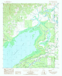
1985 Map of Bird Island Point
USGS Topo · Published 1985About this map
Lake Catahoula dominates this 1980s landscape, serving as a massive basin for a complex network of bayous and rivers along the border of La Salle and Catahoula Parishes. The ephemeral nature of the water is evident in the transition from the lake bed to the Catahoula National Wildlife Refuge and the Saline State Wildlife Management Area. Numerous waterways like French Fork, Muddy Bayou, and Little Lake Slough converge here, illustrating the hydrologic importance of the area.
Find a feature on this map
39 named features on this map. Tap any name to fly to it.
Don’t see what you’re looking for? This feature index may not catch every label — zoom into the map to look around manually.
Map Details
Editions of this 1985 Bird Island Point Map
This is the sole edition of this map. No revisions or reprints were ever made.
Other maps of this area

1935 · Tooleys
USGS Topo · 1:62,500

1941 · Manifest
USGS Topo · 1:62,500

1941 · Jena
USGS Topo · 1:62,500

1941 · Buckeye
USGS Topo · 1:62,500

1941 · Tooleys
USGS Topo · 1:62,500

1953 · Alexandria
USGS Topo · 1:250,000

1953 · Natchez
USGS Topo · 1:250,000

1955 · Alexandria
USGS Topo · 1:250,000

1956 · Natchez
USGS Topo · 1:250,000

1958 · Jena
USGS Topo · 1:62,500