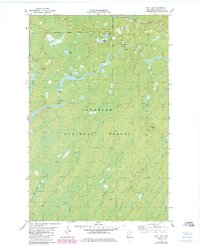
1981 Map of Bird Lake
USGS Topo · Published 1985About this map
The St Louis River winds through the heart of this landscape, characterized by the dense woodlands of the Superior National Forest and the industrial activity of the Mesabi Range era. In the northern reaches, the Duluth Missabe and Iron Range railroad skirts the edge of the Hoyt Lakes Corporate Boundary, reflecting the region's historical dependence on iron ore transport. Local geography is defined by a series of small, interconnected water bodies and streams, including Bird Lake, Lillian Lake, and the uniquely named Bum Creek. A Heliport and several Gravel Pits indicate mid-twentieth-century industrial and logistical infrastructure, while the Skibo Vista offers a point of orientation within the expansive forest. The drainage patterns of Water Hen Creek, Shiver Creek, and Little Shiver Creek detail the hydrography of this northern Minnesota wilderness before extensive modern development altered the remote character of the St. Louis County interior.
Find a feature on this map
16 named features on this map. Tap any name to fly to it.
Don’t see what you’re looking for? This feature index may not catch every label — zoom into the map to look around manually.
Map Details
Editions of this 1981 Bird Lake Map
2 editions found
Other maps of this area

1949 · Aurora
USGS Topo · 1:24,000

1949 · Allen
USGS Topo · 1:24,000

1950 · Allen
USGS Topo · 1:24,000

1950 · Aurora
USGS Topo · 1:24,000

1951 · Babbitt SW
USGS Topo · 1:24,000

1954 · Two Harbors
USGS Topo · 1:250,000

1954 · Hibbing
USGS Topo · 1:250,000

1957 · Two Harbors
USGS Topo · 1:250,000

1957 · Hibbing
USGS Topo · 1:250,000

1957 · Brimson
USGS Topo · 1:62,500