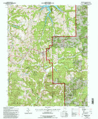
1993 Map of Birdseye
USGS Topo · Published 1996About this map
Ferdinand State Forest and the Hoosier National Forest dominate this Southern Indiana landscape, where public timberlands meet small rural settlements. The town of Birdseye sits centrally along the Southern railroad line, serving as a historic junction for the surrounding hill country. To the north, the waters of Patoka Lake reach into the quadrangle near the Dubois and Crawford County line, a significant alteration to the drainage patterns of Lick Fork. Local history is preserved in several family and community landmarks, including the Waddle Cem, Davis Cem, and Spencer Cem. The topography is defined by the winding course of the Anderson River and its many tributaries like Sigler Creek and Hurricane Creek, illustrating the complex drainage of the Crawford Upland before these waters reach the Ohio River basin.
Find a feature on this map
36 named features on this map. Tap any name to fly to it.
Don’t see what you’re looking for? This feature index may not catch every label — zoom into the map to look around manually.
Map Details
Editions of this 1993 Birdseye Map
This is the sole edition of this map. No revisions or reprints were ever made.
Other maps of this area

1900 · St Meinrad
USGS Topo · 1:62,500

1903 · St. Meinrad
USGS Topo · 1:62,500

1954 · Dubois
USGS Topo · 1:24,000

1955 · Saint Anthony
USGS Topo · 1:24,000

1956 · Greenbrier
USGS Topo · 1:24,000

1956 · Taswell
USGS Topo · 1:24,000

1956 · Vincennes
USGS Topo · 1:250,000

1957 · Vincennes
USGS Topo · 1:250,000

1957 · Cuzco
USGS Topo · 1:24,000

1957 · Birdseye
USGS Topo · 1:24,000