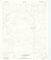
1962 Map of Birdwell Ranch
USGS Topo · Published 1981About this map
Birdwell Ranch serves as the central hub of activity in this West Texas landscape, which is defined by the shallow depression of Blackwater Draw cutting across the northern reaches. The area is characterized by a sparse, specialized industrial and agricultural footprint, where numerous wells and several Gravel Pits indicate the extraction of local resources. A large Feedlot in the south, combined with the presence of a Jeep Trail, underscores the ranching and livestock operations that dominate this portion of Bailey County. The terrain is marked by intricate contouring and small depressions, suggesting the delicate drainage patterns typical of the High Plains before modern intensive development altered the surface hydrology.
Find a feature on this map
6 named features on this map. Tap any name to fly to it.
Don’t see what you’re looking for? This feature index may not catch every label — zoom into the map to look around manually.
Map Details
Editions of this 1962 Birdwell Ranch Map
2 editions found
Other maps of this area

1954 · Clovis
USGS Topo · 1:250,000

1957 · Clovis
USGS Topo · 1:62,500

1957 · Arch
USGS Topo · 1:62,500

1958 · Clovis
USGS Topo · 1:250,000

1962 · Stegall
USGS Topo · 1:24,000

1962 · Birdwell Ranch
USGS Topo · 1:24,000

1962 · Baileyboro NE
USGS Topo · 1:24,000

1962 · Baileyboro
USGS Topo · 1:24,000

1963 · Lariat
USGS Topo · 1:24,000

1963 · Progress
USGS Topo · 1:24,000