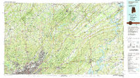
1984 Map of Birmingham North
USGS Topo · Published 1988About this map
The industrialized heart of North-Central Alabama meets the steep ridges of the Appalachian foothills in this mid-1980s survey. Dense urban development radiating from Birmingham and Fairfield transitions into the steep, parallel folds of Sand Mountain, Straight Mountain, and Blount Mountain. These topographical barriers define the region's transport and settlement patterns, funneling major routes like I-59 and the Southern Railway through the narrow valleys of Pine Ridge. The map captures the Coosa River valley as a series of major impoundments, most notably Logan Martin Lake and Neely Henry Lake, which replaced the older river navigation with extensive recreational shorelines and hydroelectric resources near Riverside and Ragland. To the west, the Locust Fork and Blackburn Fork carve through more broken terrain, providing a counterpoint to the concentrated steel and rail infrastructure of the Village Creek and Valley Creek corridors. Local history is anchored by landmarks such as Rickwood Caverns State Park and community centers like Crumley Chapel.
Find a feature on this map
97 named features on this map. Tap any name to fly to it.
Don’t see what you’re looking for? This feature index may not catch every label — zoom into the map to look around manually.
Map Details
Editions of this 1984 Birmingham North Map
2 editions found
Other maps of this area

1885 · Gadsden
USGS Topo · 1:125,000

1888 · Cullman
USGS Topo · 1:125,000

1888 · Gadsden
USGS Topo · 1:125,000

1889 · Springville
USGS Topo · 1:125,000

1889 · Birmingham
USGS Topo · 1:125,000

1890 · Bessemer
USGS Topo · 1:125,000

1890 · Talladega
USGS Topo · 1:125,000

1891 · Ashland
USGS Topo · 1:125,000

1892 · Cullman
USGS Topo · 1:125,000

1892 · Birmingham
USGS Topo · 1:125,000