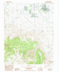
1984 Map of Bishop
USGS Topo · Published 1984About this map
Owens Valley settlement patterns are clearly defined in this mid-1980s provisional study, showing the city of Bishop anchored against the eastern slopes of the Sierra Nevada. The map details the complex water management of the region, where the North Fork and South Fork of Bishop Creek converge near the Bishop Indian Reservation. The industrial footprint of the era is evident through several mining operations including the Chipmunk Mine, Rossi Mine, and Bishop Mine, while the southern edge of the quadrangle reaches the thermal waters of Keough Hot Springs.
Find a feature on this map
42 named features on this map. Tap any name to fly to it.
Don’t see what you’re looking for? This feature index may not catch every label — zoom into the map to look around manually.
Map Details
Editions of this 1984 Bishop Map
2 editions found
Other maps of this area

1912 · Mt. Goddard
USGS Topo · 1:125,000

1913 · Bishop
USGS Topo · 1:125,000

1947 · Mariposa
USGS Topo · 1:250,000

1948 · Mariposa
USGS Topo · 1:250,000

1948 · Mt. Goddard
USGS Topo · 1:62,500

1949 · Mt. Tom
USGS Topo · 1:62,500

1949 · Bishop
USGS Topo · 1:62,500

1950 · Big Pine
USGS Topo · 1:62,500

1951 · Mt. Tom
USGS Topo · 1:62,500

1951 · Mt. Goddard
USGS Topo · 1:62,500