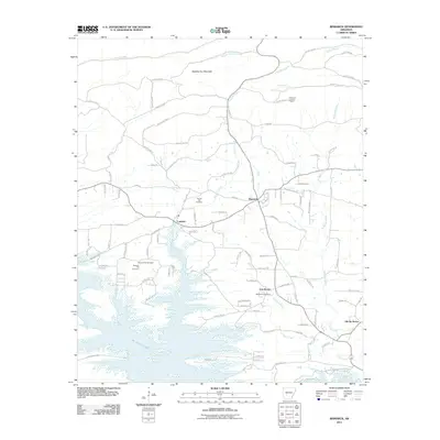
2011 Map of Bismarck
USGS Topo · Published 2011About this map
Bismarck and the surrounding Hot Spring County countryside are defined by the expansive waters of De Gray Lake and the rising slopes of Needles Eye Mountain. This 2011 survey captures a landscape where small, established settlements like Lambert, Oak Bower, and Old De Roche are connected by a network of county roads. The importance of local heritage is evident in the several burial grounds shown, including Forrest Hill Cemetery and Pleasant Hill Cemetery. Toward the north, the terrain becomes more varied as Big Hill Creek and Fourche a Loupe Creek wind through the hills near the Bismarck Lookout Tower. The southern portion of the map highlights the recreational and natural landscape of the De Gray Lake Resort State Park, showing how modern conservation and infrastructure have shaped this portion of Arkansas.
Find a feature on this map
100 named features on this map. Tap any name to fly to it.
Don’t see what you’re looking for? This feature index may not catch every label — zoom into the map to look around manually.
Map Details
Editions of this 2011 Bismarck Map
This is the sole edition of this map. No revisions or reprints were ever made.
Other maps of this area

1943 · Antoine
USGS Topo · 1:62,500

1955 · Little Rock
USGS Topo · 1:250,000

1956 · Little Rock
USGS Topo · 1:250,000

1959 · Caddo Valley
USGS Topo · 1:24,000

1960 · Little Rock
USGS Topo · 1:250,000

1964 · Little Rock
USGS Topo · 1:250,000

1966 · Pearcy
USGS Topo · 1:24,000

1966 · Hempwallace
USGS Topo · 1:24,000

1966 · De Roche
USGS Topo · 1:24,000
1966 · Point Cedar
USGS Topo · 1:24,000